(August 30) – The Gettysburg Battlefield Preservation Association has given the Straban Township
Planning Commission and the Township Supervisors a detailed letter outlining its concerns over proposed new development between Route 30 (York Pike) and Route 116 (Hanover Pike).
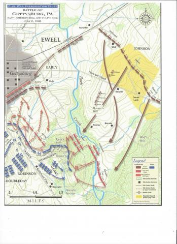
The development encompasses property that was known as the Wolf Farm at the time of the Battle of
Gettysburg in July 1863. It is one of the last undeveloped portions of battlefield and aftermath property around the Gettysburg National Military Park.
The property is threatened by the proposed development of a new Wal-Mart super store and additional
commercial structures along with access roads.
The GBPA letter outlines four areas of concern:
1. The Confederate line as it assembled for the assaults of East Cemetery Hill and Culp’s Hill.
2. The location of Confederate artillery on the Wolf Farm that engaged Union forces on East Cemetery Hill
and Culp’s Hill.
3. The east bank of Rock Creek that was the route of Ewell’s 2nd Corps Troops of Gordon’s Brigade took in
preparation for their assault on Culp’s Hill.
4. Plans for a connecting road between busy Route 30 (York Pike) and State Route 116 (Hanover Pike).
“The GBPA has previously stated its concerns about the impact of commercial development bordering the Park and the Daniel Lady Farm,” states the letter. “Both the Park and the GBPA are concerned that future plans respect the historic view-shed from the Park and the Historic District and that insensitive development does not close off the opportunity to interpret the sacrifice and contributions made here by soldiers, doctors, nurses and civilians of Gettysburg.“
The letter emphasizes the property is part of the “hallowed ground” described by President Abraham
Lincoln in this Gettysburg Address of 1863.
“At the very least, the developer and the Township need to complete a serious review of the historically
significant events and resources impacted by the development,” the GBPA letter states. “As part of that review, the developer should produce a map overlay of historic features and resources and incorporate a plan to preserve, interpret and mitigate damage to those resources.”
Both the Daniel Lady Farm and the Wolf Farm were important staging areas for Confederate troops and
artillery throughout the battle for Culp's Hill as well the evacuation route at the battle's end.
Click here to view the letter.
Click here for a map of the historic districts.